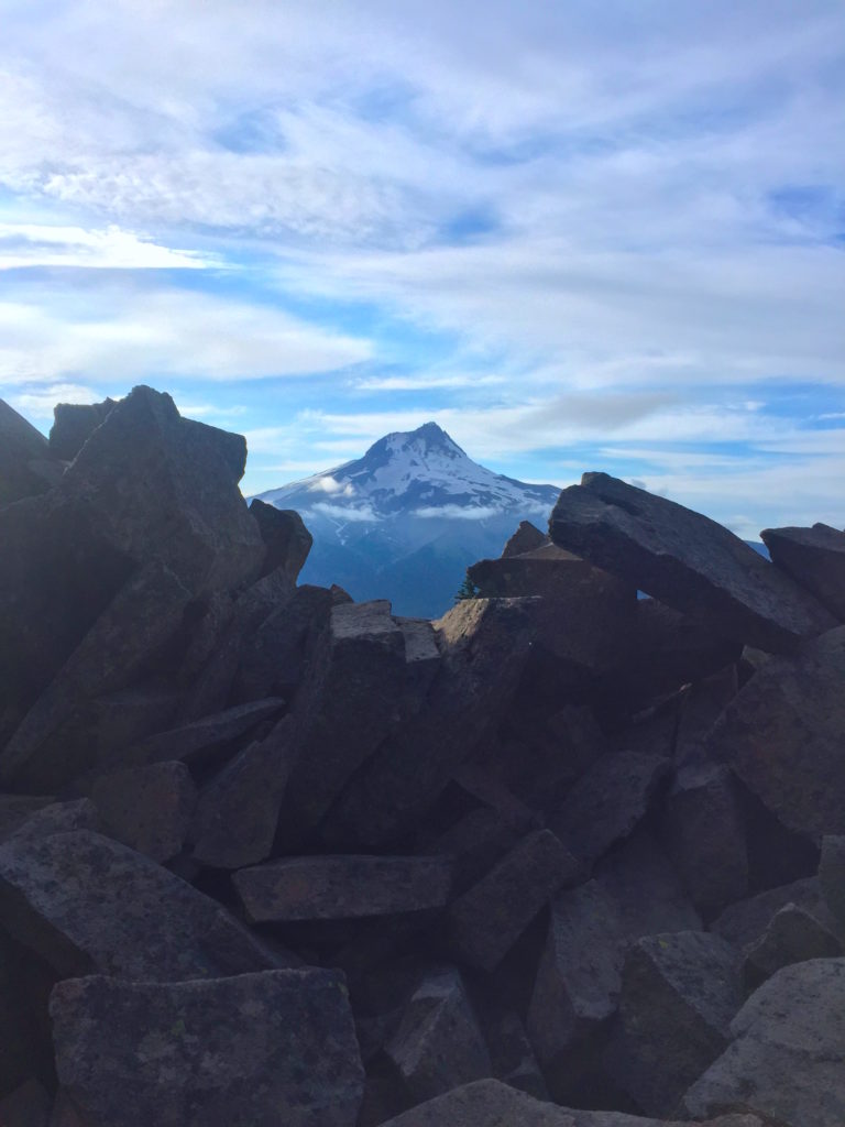
The Wy’east Wonder 50-mile course is stunning. You will have so many views of Mt. Hood, as you make your way from the southern side of the mountain, around to the east. You’ll also be treated to vistas of eastern Oregon’s desert and the Hood River Valley orchards. The single-track is super fun and includes some relatively newly created trails.
The start of the race is on a double track road. It’s a bit steep, with ~700′ of gain. You’ll start seeing the views of Mt. Hood early on as you make your way on Forest Road 3550. You’ll turn onto the Gunsight trail and run along Gunsight Ridge, heading north and east. You aren’t required to step off the trail a few feet for the iconic ‘gunsight’ view of Mt. Hood, but you’ll probably want to. You can consider this a personal aid station where you pause to eat the GU you were carrying. This section also includes the fun-to-say Gumjuwac Saddle, which is where you’ll leave the Gunsight trail to race on Forest Road 3550 to the first aid station at High Prairie.
Immediately upon leaving the High Prairie Aid Station, you’ll have a really fun downhill through the woods. After crossing road 4410, you continue on the Cooks Meadow trail until you get near the aquaduct. This old, buried pipe is used to distribute water to The Dalles Watershed. In the last couple of miles you’ll be on the Surveyor’s Ridge trail with a 500′ climb and then descent into the aid station.
Leaving the aid station, you’ll run east on the Super Connector. Lots of little switchbacks as you make your way up to the Knebel Springs trail and onto the Bottle Prairie Aid Station. Elk have been spotted along here.
This section is a loop on the Eightmile trail… but don’t worry, it’s only 6.4 miles. You’ll have views toward the desert and farmlands of eastern Oregon at Perry Point. The course passes near a fire lookout you may want to check out on another trip. You’ll also have a view to some Cascade mountains to the north. There is a fun, twisty downhill section here to take you near the Eightmile creek. The trail returns to the Bottle Prairie Aid Station and has some sustained climbing that will make you happy to arrive at the aid station.
After leaving the Bottle Prairie Aid Station for the second time, you’ll run on the rest of the Knebel Springs trail. This is another fun section of the course, with some welcome descent and small creek crossings before you grind back up to the Super Connector where you return to the Aquaduct Aid Station.
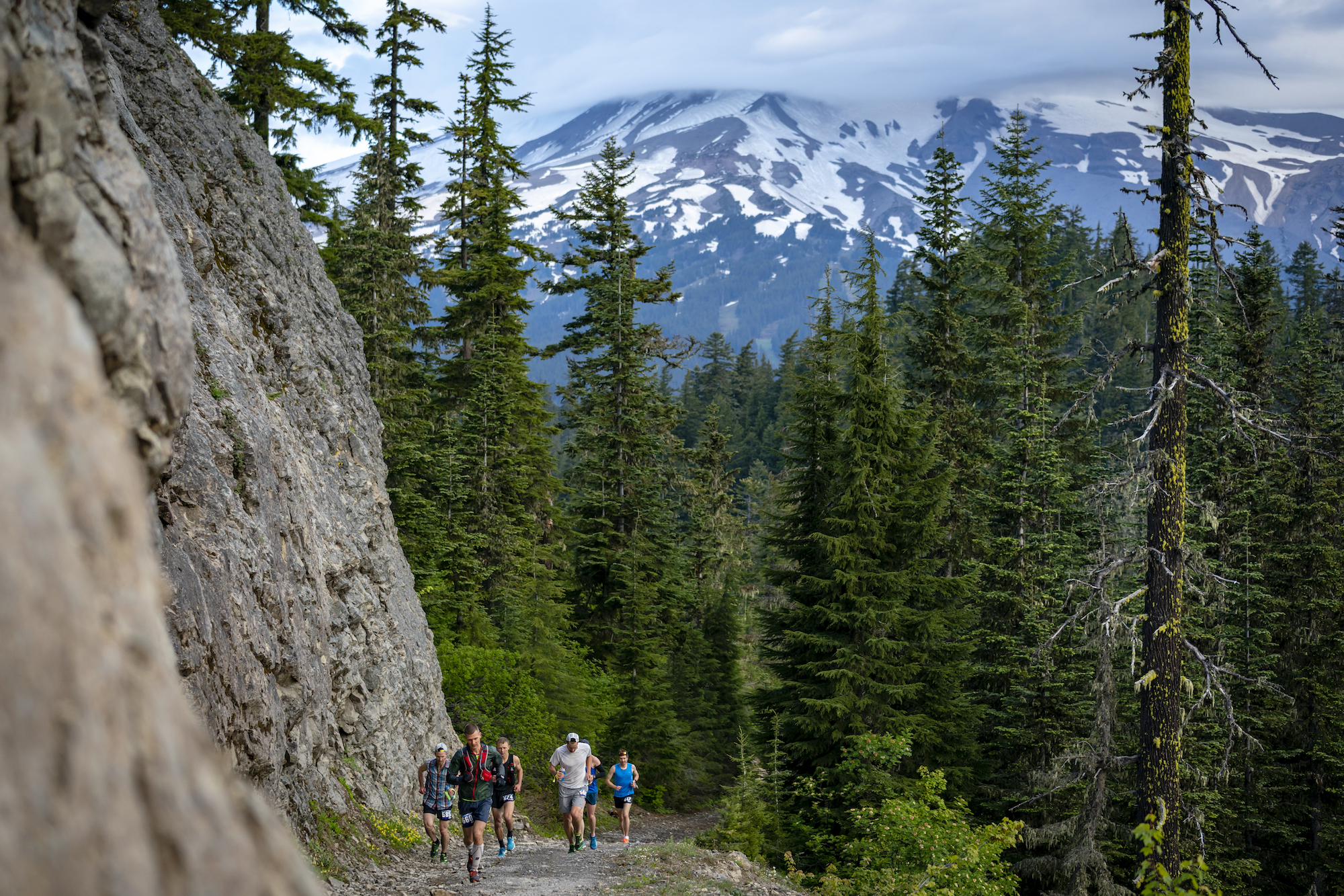
Now you are running on the stunning Surveyors Ridge! Get ready for many more stunning views of Mt. Hood, as you traverse this ridge through meadows and prairies. You’ll pass Shellrock Mountain and the Badlands Basin and will want to peek at the pinnacles and ridges formed out of the pyroclastic flow from a long-ago Mt. Hood eruption. You will also begin seeing the Hood River valley and all the orchards down below you.
Continuing north on Surveyors Ridge, you’ll run almost 3 miles before reaching the intersection with Oak Ridge trail. Yeah, yeah, there are more views of the valley and the mountain. You will still be tempted to stop to take a picture. The last section on Oak Ridge trail is a sturdy and rocky downhill, where you’ll drop almost 2,000′ in a bit over 2.5 miles. Then you’ll finish up on double-track road to the finish arch!
View the 50M course interactive map in Caltopo, where you can change the layers and views, zoom in and out and move around the course.
The course has 7,600′ of gain and 10,600′ of loss.
Aid stations are stocked with water, GU electrolyte drink, GU gels, potato chips, Fritos, Fig Newtons, pickles, gummy bears, bananas, and M&Ms.
Go Beyond Racing is cupless. You’ll need to bring your own cup for liquid aid at all aid stations.
| Aid Station | Segment Distance |
Cumulative Distance |
Cutoff |
|---|---|---|---|
| High Prairie | 10.7 | 10.7 | |
| Aquaduct | 9.8 | 20.5 | 11:30 a.m. |
| Bottle Prairie | 4.3 | 24.8 | |
| Bottle Prairie | 6.4 | 31.2 | 2:00 p.m. |
| Aquaduct | 8.9 | 40.1 | 4:30 p.m. |
| Gibson Prairie | 4.7 | 44.8 | |
| Finish | 5.4 | 50.2 |
Pacers are not allowed in this race.
Small crews can access their runners at the Aquaduct aid station, and only at this aid station. Runners pass through here twice, so there are two opportunities to see and support racers. Crew can park on the right side of Forest Road 17, south of where the runners cross the road to get to the Super Connector trail, or where directed by volunteers. Runners receiving aid from crew at any other location will be disqualified.
Driving directions to Aquaduct aid station. This is all paved and easily accessible by any car. If you leave the aid station and head north on Forest Road 17, be aware that the road has some gravel sections (it is not all paved) and there are potholes to watch out for. Also, be aware that there is construction occurring in this area on the aquaduct.
There are three cutoffs in the 50-mile race. Runners must depart the aid station by the cutoff time to be allowed to continue the race. If you miss a cutoff, you will stay with the volunteers until they close down the aid station and they will transport you to the Red Barn Park.
50-mile racers can have one drop bag for the Aquaduct aid station. You pass through this aid station twice. You will leave your drop bag at Bennett Pass Sno Park before the start. We will transport your drop bag to the aid station. All drop bags will return to the Red Barn Park when the Aquaduct aid station closes. Don’t forget to retrieve your drop bag before heading home.
Please read our guidelines about drop bags.
Additionally, you can drop the coat that you wear on the shuttle to the race start, at the starting line. We will transport these items to Red Barn Park.